More Lake-Effect Snow To Blanket Hard-Hit Great Lakes Snowbelts
- Gaming With Dj Pumpkin
- Dec 3, 2024
- 3 min read

Hello everyone my name is Luna longhorn and I'm joined by Gaming with DJ Pumpkin and we are here to share with you all the latest weather and this report name is More Lake-Effect Snow To Blanket Hard-Hit Great Lakes Snowbelts and the time is 10:32AM and today date is 12/3/2024 and let get into this new:
Luna: Good afternoon Gaming with DJ Pumpkin how are you today?
Gaming with DJ Pumpkin: Good Afternoon Luna i'm good
Luna: Can you please tell us all about More Lake-Effect Snow To Blanket Hard-Hit Great Lakes Snowbelts?
Gaming with DJ Pumpkin: yes i can tell you all about More Lake-Effect Snow To Blanket Hard-Hit Great Lakes Snowbelts:
At a Glance
Parts of the Great Lakes snowbelts picked up over 4 feet of snow over the holiday weekend.
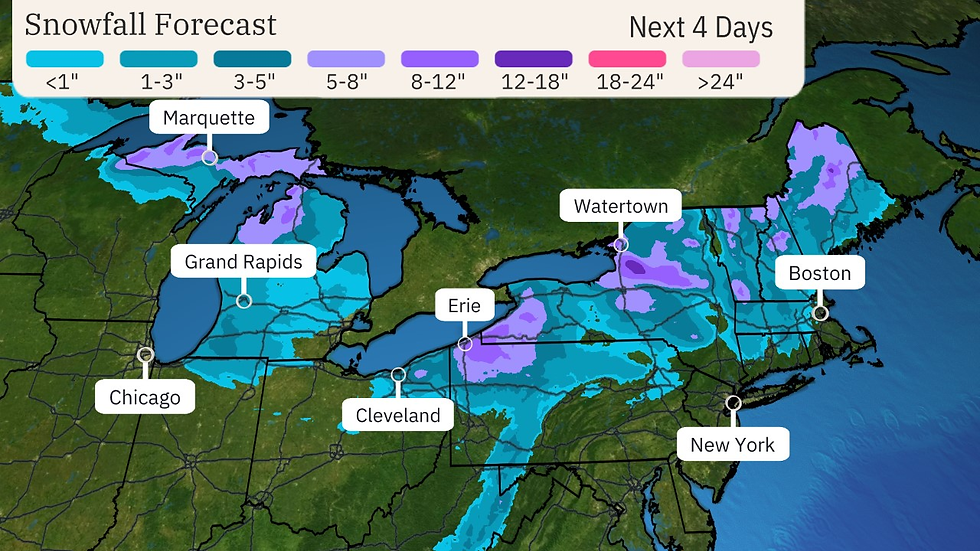
Lake snow will continue through late Thursday or Friday.
A powerful cold front will also bring strong wind gusts and snow squalls Wednesday into Thursday.
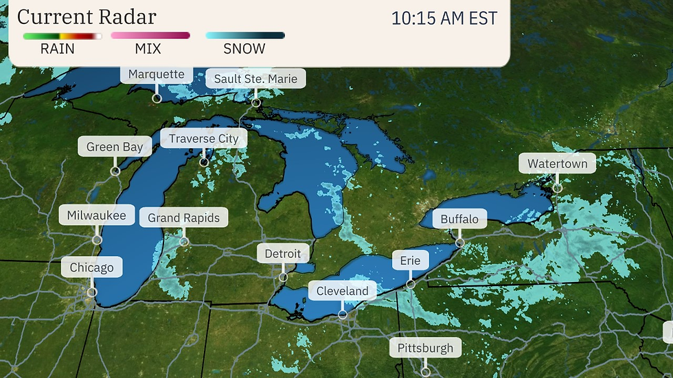
Various winter weather alerts have been issued by the National Weather Service in the Great Lakes snowbelts for both ongoing snow and the next round set to arrive Wednesday through Thursday.
More ahead: A powerful cold front meteorologists call an "Alberta Clipper" will plunge south out of Canada into the Midwest Wednesday, then into the Northeast Wednesday night into early Thursday.
Given the strength of this cold front and accompanying jet stream, brief bursts of snow called snow squalls may accompany the cold front as it slices through the Great Lakes Wednesday and Wednesday night.
Together with strong winds both ahead of and behind the front, these snow squalls may lead to sudden, dangerous reductions in visibility and quick accumulations on dry roads. Keep this in mind even if driving in areas outside the Great Lakes snowbelts Wednesday and Wednesday night.
Those cold winds pouring over the still warmer Great Lakes will regenerate lake snowbands Wednesday into Thursday before they fizzle from west to east by Friday.
We don't expect this second round of lake snowbands to last as long, nor wring out as much snow, as the holiday weekend event. Some areas will pick up another foot of snow, especially in northwest Pennsylvania through early Friday.
Feet of snow last weekend: The first real widespread lake snow event of the season over the holiday weekend dumped over 4 feet of snow in several locations from northeast Ohio and northwest Pennsylvania, parts of southwest and upstate New York and Ontario, Canada.
Among the state leaders were Castorland, New York (65.9 inches); Saybrook, Ohio (61.2 inches); Girard, Pennsylvania (59.3 inches); Otsego Lake, Michigan (46.7 inches); and Echo Bay, Ontario (136 cm or 53.5 inches).
Erie, Pennsylvania, had only 0.1 inch of snowfall for the season through Thanksgiving. They, then picked up 22.6 inches of snow on Black Friday, alone, their record heaviest calendar-day snow.
Sault Ste. Marie, Michigan, had their record longest wait for their first measurable snow of the season, which arrived over a month later than average on November 25. But they were then buried by 42 inches of snow over the last six days of November, almost three times the monthly average.
In western New York, the heaviest snow totals were in the southern tier counties of Chautauqua and Cattaraugus Counties where a pair of locations picked up 53 to 54 inches. However, the Buffalo metro's "Southtowns" were also hit with 1 to 3 feet of snow. That included Orchard Park, where the NFL's Buffalo Bills hosted the San Francisco 49ers Sunday night following an effort to both clear out parking lots and stadium.
Luna: Thanks for sharing this with us all and thanks for listening everyone bye.


Comments